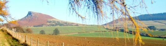
Roseberry Topping the area's iconic mini Matterhorn.
Roseberry Topping's familiar hook-nosed profile dominates the skyline for miles around and is an icon of the North York Moors. The Topping used to have a rounded sumit until a landslide in 1912 created its distinctive top. The name is derived from the Old Norse 'Othensberg', meaning Odin's Hill, and 'toppinn', meaning hilltop. Roseberry Topping lay wholly within the North Riding of Yorkshire until 1974, when boundary changes left it half in North Yorkshire and half in Cleveland. Additional changes in 1996 placed the northern half of the Topping in the borough of Redcar & Cleveland.
Odin's Glow
2009 marked one of the most spectacular public events in Roseberry Topping's history. Over four days in October an exciting programme of son et lumiere entertainment was held on the Topping. Odin's Glow saw the entire hill illuminated in a sensational display of lighting and pyrotechnics. Open-air art works were positioned around the hill and performers, fellrunners and hillwalkers added to the spectacle. A result of a colaboration between Redcar & Cleveland Council, Culture 10, the National Trust and the North York Moors National Park Authority, the event was intended as a celebration of the historic and cultural importance of Roseberry Topping to the people of Cleveland, to the National Park and to walkers on the Cleveland Way which takes a detour to the summit.
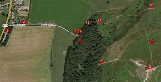
Roseberry Topping - the walk to the summit. Distance 2 miles.
The summit of Roseberry Topping presents the walker with wide horizons and see-for-miles views. Towering over the landscape, it guarantees a memorable walk, with the climb up as fantastic as the breathtaking sights from the top.
Start - Parking
There is a public car park at the junction of Roseberry Lane, Newton-under-Roseberry on the A173 between Guisborough and Great Ayton. OS Map Grid Reference NZ571128
Basic Route
- From the car park turn right to walk up Roseberry Lane.
- Pass through the gate and continue to walk up the lane.
- At the top of the lane go through another gate and then turn right to walk through the woodland. (There are two paths here but they meet up again after a short distance.)
- Follow the lane through Newton Wood.
- At the top of the hill pass through the gate and bear left passing a shooting box on your right.
- Follow the grassy path to the Roseberry Topping information board and pass through the gate next to it.
- Follow the well marked path up the hill keeping the fence on your right.
- Opposite a small gate on your right the path bends to your left - follow the path towards the summit.
- Take in the views from the trig point!
- When you are ready you can return to the Car Park by the same route that you arrived... OR...
- Walk a little way beyond the trig point passing a metal post on your left.
- At the second metal post turn left and walk down a narrow stepped path.
- Walking down the winding path you will shortly pass two large rocks on your left where the path splits, continue following the grassy path on your right.
- Continue walking straight downhill, passing over two sets of crossroads in the pathway.
- At the next junction turn left and continue to walk downhill.
- At the bottom of the hill continue on the right hand pathway, ignoring the path to your left.
- Pass over the style and walk along the cobbled woodland path.
- Follow the path through the woods as it bends to the left.
- Pass through the next gate on your right and walk down Roseberry Lane to the car park.