

Saltburn Gill, Saltburn's 52 acre woodland nature reserve.
Saltburn Gill is a 52 acre woodland nature reserve nestling in the shadow of Saltburn by the Sea, where drifts of Wild Garlic and Bluebells herald the arrival of Spring and where sightings of Roe deer are always a possibility.
About Saltburn Gill.
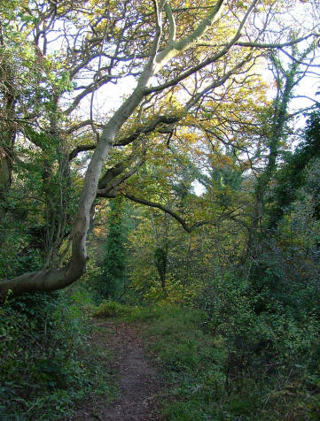
Saltburn Gill is an ancient semi natural woodland which means that woodland has been present continuously since 1600. A stream of the same name runs along its western boundary. The reserve is a good example of the type of woodland that would once have covered East Cleveland with a mixture of Oak and Ash, with a Hazel and Holly understorey. Prior to the arrival of Dutch elm disease Wych Elm would also have been a common tree but has been replaced by Sycamore, which has to be managed. Because of the variety of animal and plant life it is designated as a site of special scientific interest. A public footpath runs through the entire length of the reserve and provides good opportunities to see all that the reserve has to offer.
Dominated by Oak and Ash, Hazel and Holly, the damp, humid conditions in the Gill make it an ideal habitat for ferns to grow, with six different species recorded.
The changing seasons...
From early spring through to autumn the woodland floor is ablaze with colour. The arrival of spring is heralded by the glossy yellow flowers of the lesser celendine, followed by early purple orchids, wood anemones and primroses. Summer sees the return of the migrants with Chiffchaffs often being the first to arrive followed by Willow Warbler, Blackcap and Spotted Flycatcher. In Autumn the falling leaves makes it easier to see the mixed tit flocks moving through the canopy as they search out the last insect before winter. These flocks can be worth a second look as there are often Treecreepers and the occasional Goldcrest tagging along with them. The Autumn is also the time for toadstools and other fungi as they help with the recycling process. The sheltered nature of the site means that in winter the temperature inside the gill is higher than outside, this makes the gill the ideal place for ferns. Hart Tongue Fern, Male fern and Broad Buckler can all be found. Common Polypody and Hard fern are also found in a few places.
In all Saltburn Gill offers the total woodland experience with something for everyone from the amateur botanist to a family out for a Sunday stroll, and you never know what’s round the corner. Look carefully and you may spot a roe deer or a weasel!
A walk in the woods...
Parking is available throughout the year in the Public Car Park below Cat Nab
Access: Due to the nature of the terrain the paths are often muddy in the winter and care should be taken when climbing the steep flight of steps. Again due to the nature of the path and ground conditions the site is not really suitable for disabled access.
From the car park below Cat Nab cross the road and head towards the Northumbrian Water pumping station (the very large red brick building). You will see the signposted public footpath. Follow this for another 300 metres until you reach the gate. You are now at the entrance of the reserve. From the reserve entrance follow the footpath up to Lum Hole (where the bridleway and footpath cross), and then retrace your steps back to the car park. To walk the length of the public footpath and back within the reserve boundary is 3km and will take about an hour.
The reserve is very close to Saltburn itself and a number of amenities are within easy reach. The Ship Inn is on the seafront and serves food throughout the year, there are also a number of beach cafes and a fish and chip restaurant serving refreshments close by. Toilet facilities are available at Cat Nab car park.
Saltburn Gill is managed by Tees Valley Wildlife Trust For guided walks, events and children’s activities please contact the Wildlife Trust on 01287 636382
Saltburn Gill, the river that legislation forgot.
Saltburn Gill Action Group
A short film illustrating the impact of ironstone mine water pollution on Saltburn Gill, Cleveland and the work of the Saltburn Gill Action Group.
A circular walk - Saltburn Cliffs
This is a 13km/8 mile moderate walk of approximately 4 hours.
 An exhilarating country walk with stunning views including the region's best vantage point to marvel at Boulby Cliffs, the highest cliffs on the east coast of England. Add in far-reaching views over the North York Moors and two fascinating nature reserves and there's never a dull moment.
Saltburn's Inclined Tramway and Victorian pier, plus golden, sandy beaches are close by.
An exhilarating country walk with stunning views including the region's best vantage point to marvel at Boulby Cliffs, the highest cliffs on the east coast of England. Add in far-reaching views over the North York Moors and two fascinating nature reserves and there's never a dull moment.
Saltburn's Inclined Tramway and Victorian pier, plus golden, sandy beaches are close by.
This walk was originally made available courtesy of VisitNorthEastEngland
We regret that a pdf file of the walk is no longer available.
Please note that the point marked C on the map is NOT Saltburn Valley Woodland Centre.
Start/Parking
Cat Nab car park situated on the lower promenade at Saltburn-by-the-Sea on the A174, signposted Woodland Centre and Miniature Railway. OS Map Grid Reference NZ666215
1 Starting at the Cat Nab car park, cross the public road and pass the waterworks on the left before reaching a footbridge. Follow a sign directing you into Saltburn Gill Nature Reserve. Cross the stile to follow a path that takes you high above the Gill. Climb steps that lead to two more stiles about 50 metres apart. Cross a footbridge as the pathway runs close to Saltburn Gill.
2 Follow the right of way up a slope before emerging into a level open area. When the path divides there is a wooden post in the centre, head to the right on the upper path with gorse bushes on the right-hand side. Pass a nature reserve information board, go through the wooden gate then make your way through the woodland ridge. Follow the path as it bends up an incline to the edge of a field.
3 Continue directly ahead towards the houses at the western edge of Brotton. Follow the track round to meet the A174. Turn left up the hill and pass under the railway bridge, to join the High Street with the Methodist Church on the left. Turn right up a flight of steps opposite No. 42. Follow the path which is covered by overhanging trees until you reach playing fields. Keeping left, walk directly ahead through a cemetery until you reach Kilton Lane. Cross the lane and turn right, then left onto Winchester Road.
4 Follow the road to the junction with Canterbury Road. Follow a walkway on the left until you catch sight of Guibal Fan House on your left. Cross a road and follow the track that runs gently downhill to pass close to Gripps Farm. The route then veers left around the perimeter of Hunley Hall golf course, then cross the stile to lead to a path close to the fence on the left-hand side. Continue left and over the stile. At the next stile a notice points out Cattersty Gill Nature Reserve, make your way left towards another stile.
5 Turn left away from Skinningrove along Cattersty Cliffs, past Guibal Fan House until you reach the metal sculptures. Follow the signs for the Cleveland Way, taking in the breathtaking views, including Roseberry Topping to the left, along the cliff tops towards a stile. Through the stile make your way down some steps and follow the roadway round to the left to reach the starting point at the Cat Nab car park.